FLX PFAS Project
What are PFAS?
Per- and polyfluoroalkyl substances, also widely known as PFAS, are a group of man-made chemicals produced for their unique chemical properties. Definitions for classifying PFAS can vary widely, resulting in thousands to millions of different PFAS species. However, most human-utilized PFAS share some similarities in physical properties, including non-degradability, anti-stick, water resistance, heat resistance, and more.
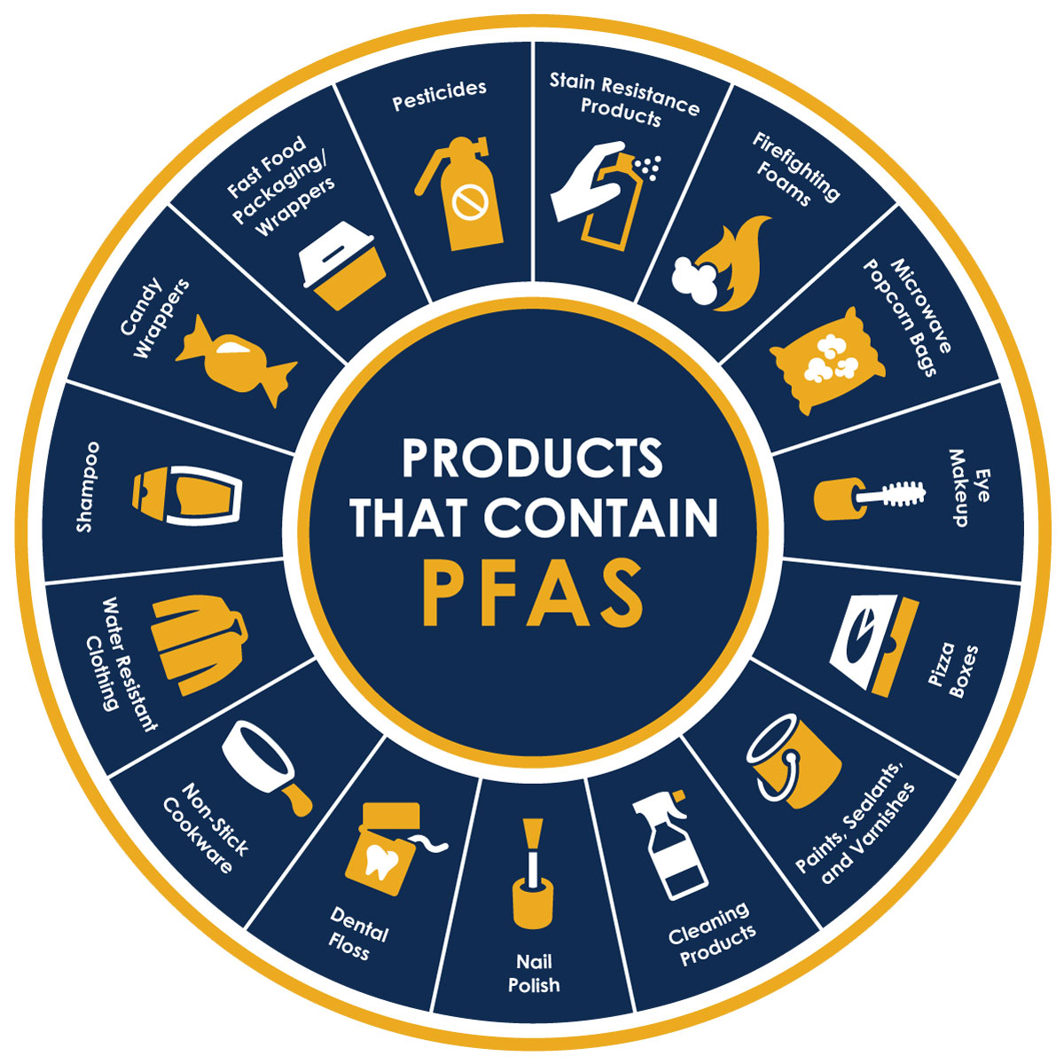
Some common items that contain PFAS include non-stick cookware, cleaning products, and rain jackets. More can be found in the image below:
https://riversideca.gov/press/understanding-pfas
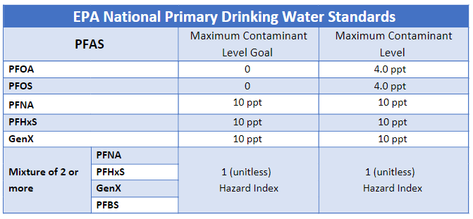
PFAS are most generally known for their non-degradability, taking up to 1000 years to degrade, which is multiple times longer than plastics. This property of non-degradability is extremely useful in some situations, yet yields a huge sustainability concern: the potential for bioaccumulation. Similar to microplastics, PFAS have been shown to bioaccumulate in humans and animals. They travel up the food chain or through drinking water into our bodies and essentially never leave. As we grow older and continue to be exposed to PFAS, the concentrations of these potentially harmful chemicals in our bodies continue to rise. Fortunately, recent progress has been made in the regulation of these chemicals, and in April 2024, the Environmental Protection Agency placed enforceable Maximum Contaminant Level’s on six of the more prevalent and harmful PFAS species in our drinking water, which are listed below:
 https://www.mass.gov/info-details/epa-maximum-contaminant-levels-mcls-for-pfas
Why is monitoring PFAS important?
With the potential for long-term effects on humans, limiting our exposure to PFAS is imperative. Drinking water is a major source of human exposure to PFAS, but current understanding of PFAS concentrations in our local environment is limited. By monitoring PFAS concentrations in the Finger Lakes region, along with providing supplementary information (such as proximity to known PFAS sources such as airports, fire stations, and other facility locations), this project aims to improve our understanding of the flow of PFAS through our local environment.
How to use this map
This interactive map includes PFAS concentration data (in units of nanograms per liter or ng/L or ppt) at various locations in the Finger Lakes region. All samples, which have been collected and tested by undergraduate student members of the Helbling Research Group, are shown as colored circles on the map.
These PFAS concentration data points are also accompanied by various supplementary layers that yield location and other data on airports, fire stations, and more in the Finger Lakes region. These layers are all known potential sources of PFAS and allow for a better understanding and analysis of the PFAS concentration data set. Layers can be toggled from the sidebar on the right of the map.
Additional information on data points of all layers can be viewed by clicking on the data points. A pop-up menu will appear with information about that specific data point.
Our Sampling Gallery


